Cabarrus Rewind provides an aerial trip through history
Published on April 24, 2025
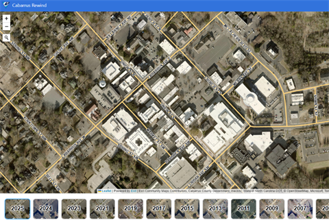
Cabarrus County’s Information Technology Services (ITS) department has launched a new way to explore the county’s history—Cabarrus Rewind.
This innovative online tool allows users to visually scroll through decades of aerial imagery, dating back to 1938. By offering a unique and interactive experience, Cabarrus Rewind provides a snapshot of the county’s transformation over the years.
The platform, accessible via location.cabarruscounty.us/cabarrusrewind/, provides clickable tiles of each year aerial imagery is available, giving users a quick way to travel through time from their screen. Users can view the entire county or use the search feature on the top left of the screen to zoom in on a specific parcel. The feature complements Map Cabarrus, the County’s Geographic Information System (GIS) website.
Map Cabarrus (location.cabarruscounty.us/mapcabarrus) provides information on properties, townships, zoning, schools, services and more and includes the aerial shots under “Map Layers.” It’s beneficial for real estate agents and developers and is integral for County departments like Planning and Development, Permitting and Tax Administration. The service also allows the Sheriff’s Office to properly route 911 calls and validate locations when responding to calls.
Aerial imaging company EagleView is contracted to fly the entire county every year. They fly at low altitudes with high-tech cameras, then stitch the images into a mosaic before uploading to Map Cabarrus. This ensures the everchanging landscape is accurately reflected.
According to ITS Business and Location Innovative Services Manager Joe Battinelli, Map Cabarrus is one the most visited pages of the County’s award-winning website, with nearly half a million visits in the last 12 months.
In addition to Cabarrus Rewind and Map Cabarrus, the County offers a variety of other services to residents and businesses via www.cabarruscounty.us, including:
- CLaRIS, a land records system that identifies all parcels and lists the taxable owner(s) of record
- Accela, a one-stop shop for all planning, reviews, zoning, permitting and inspection services
- myCabCo, a quick and easy way to pay property taxes online
About Cabarrus County ITS
ITS aligns with customers across government and throughout the community to deliver quality technology services. They foster a culture of innovation while providing access to information resources, promoting enterprise information processes and protecting information integrity.